The fascination with the power of the sea has always been with us.
Looking at the Caribbean Sea, the notion of 'One Sea' is clear because with Sea Level Rise (SLR), no country will be spared. The Caribbean Sea neither separates nor brings together, it just is. And the sea is the attraction for most visitors. The impacts of climate change aren't just about heat waves, flooding and forest fires, coastal impacts are also very much part.
"Once set in motion, the breakup of ice sheets and the contribution to SLR are irreversible on human timescales. Considering this and analogues of sea level during periods with similar climatic conditions as today (when sea levels were an estimated 3-6m above current levels), then the question is not if the Caribbean will face SLR of 1m or 2m under either a 2.0°C or 2.5°C global warming scenario, but rather when." (Modelling the Transformational Impacts and Costs of Sea Level Rise in the Caribbean, Caribsave, 2011, pg 61)
That was twelve years ago, we know more now.
So, with the release of news about the melting zombie ice in the Greenland ice sheet (GIS) late in August 2022, the World view on sea level rise has changed dramatically. Zombie ice is real and it is melting.
"The major 2007 report from the IPCC underscored that uncertainty: the report projected a sea level rise of between 7 inches and 2 feet by the end of the century — but added a note saying the projections “[excluded] future rapid dynamical changes in ice flow.” In short, the projections were incomplete, and had to be taken with a grain of salt.
Since then, scientists have observed an acceleration in ice flow, mostly in Greenland. They’ve also learned more about how ice responded to warming episodes in the distant past. With this new information, they now agree that rather than rising between 7 inches and 2 feet, the seas are likely to rise between two and seven feet by century’s end, with about three feet being the most popular estimate.
Local increases, however, will vary to some degree from the global change." (Sea Level Projections @ climatecentral.org)
Any previous projections about how much SLR will occur has just been increased by about 10.8 inches or 27.4cm. Some previous projections may have already shown increases in the mid to high range which, in effect already take a certain amount of this increase into their models but this new information almost certainly makes lower range estimates out of date.
The time range over which this change will take place is about the next 30 - 50 years. It can't be stopped. Greenland is 6,000km away from the Caribbean but the melting ice will cause sea levels to rise, more or less, worldwide.
Worldwide, former expectations of a 10cm SLR in the next 30 years can now realistically expect 37cm SLR. If 15cm was the projected SLR, now this amount may be closer to 42cm. Looking at the projections to 2080, this value becomes a half a metre, or possibly more. Scientists tend to be fairly cautious with their estimates, so this is probably a conservative projection.
People living in coastal areas need to prepare now.
"In Latin America and the Caribbean more than 27% of the population live in coastal areas, with an estimated 6–8% living in areas that are at high or very high risk of being affected by coastal hazards. Low lying Caribbean states are especially vulnerable.
It is estimated that 6–8% of the population live in areas that are at high or very high risk of being affected by coastal hazards. The number of people living below the hundred-year extreme sea level events (ESL) is projected to increase." (New report shows impacts of climate change and extreme weather in Latin America and Caribbean)
In the Caribbean, actually, SLR has been happening at a slightly faster pace, around 3.6mm/year, above the 3.3mm/year that is the worldwide average.
"Averaging 3.6 mm per year, between 1993-2020, sea level in the Caribbean has been rising at a slightly higher rate than the global average (3.3mm/year)." (New report shows impacts of climate change and extreme weather in Latin America and Caribbean)
With the release of the new information about the melting zombie ice, the average annual sea level rise is probably closer to 6mm.
In any location already susceptible to coastal flooding, mangrove destruction or storm surges, this new projection means potentially devastating conditions. And how inundation of seawater into local fresh water supplies will impact access to drinking water is also a matter for serious concern. Turtle nesting beds are also at risk. Other impacts, such as on fish breeding areas or any other coastal species will also be felt. Wave action associated with high tides will reach further onshore.
"Furthermore, one must recall that these hurricane storms are usually accompanied by heavy rainfalls that can exacerbate the level of flooding". (Sea Level Rise and Storm Surges: Vulnerability Mapping by Professor Dr. Bhawan Singhn and Dr. Calin Obretin)
So, a place like Sheerbirds Point, or what is commonly known as No Man's Land, in Tobago is going to be at least partially submerged or possibly washed away in the next few decades. This should make Prime Minister Dr. Keith Rowley somewhat relieved that his coveted Sandals/Beaches project in Tobago was rejected because its attractiveness will be seriously damaged. It should also awaken the Tobago and TnT governments to the reality of what climate change and the accompanying sea level rise are going to look like. Not pretty. In fact, due to the increasing severity of storms and related storm surges, wind damage or more intense wave action, it may well happen long before 30 years from now. The fact is that we are already witnessing more severe coastal damage from storms.
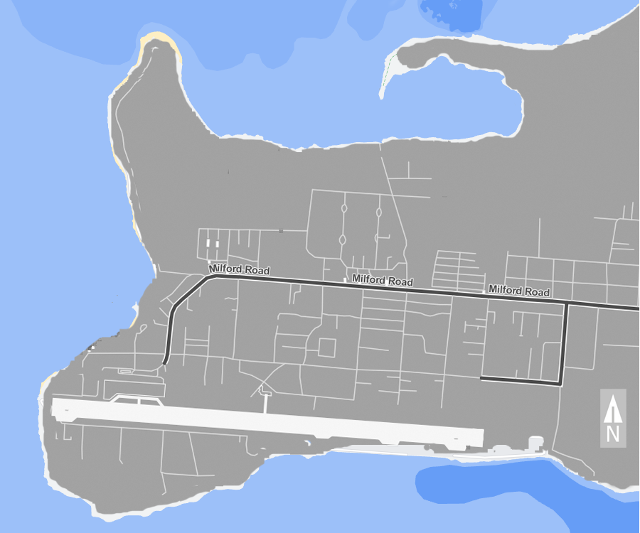
Approximate extent of 1m of sea inundation in Crown Point, Tobago (sources: Google Maps and Surging Seas Risk Zone Map)
The image shows the approximate areas where the Caribbean sea is likely to inundate areas around Crown Point in Tobago. It is intended only to give an idea of what might happen and is not completely precise due to errors in imaging. The light grey areas show the current coastline according to Google Maps. The darker grey area is the projected land area after a 1m sea level rise, roughly as shown on the Surging Seas Risk Zone Map with some modifications to make it look more realistic so some errors may also be included. The large light grey bar at the bottom is the runway at ANR Robinson airport. So particularly distressing is the extent to which the runway may be inundated at the eastern end. Other locations in Tobago will be affected just as severely. Goat Island, in Tyrrel's Bay, for example, will almost completely disappear along with parts of Lucy Vale including the road.
Elsewhere in the Caribbean, Grand Cayman will almost completely disappear as will half of Little Cayman. Falmouth, Negril and Montego Bay in Jamaica will experience severe inundation as well as the runway at Sangster International Airport that will need major repairs on an ongoing basis. Better to relocate it.
Other [a]irports too are affected. This WorldBank article states: "Typically built in flat coastal areas, airports such as Melville Hall, Dominica; Maurice Bishop, Grenada; and Hewannorrah, St Lucia, are dealing with increased flood risk and sea level rise."
Most of the Cayos in northern Cuba will become submerged along with major areas of Andros, Grand Bahama, Key West, Lucaya and south Florida. In the west, Belize faces huge areas that will soon be underwater as does Cancún. And so on. It is a very desparate situation that the Caribbean is facing. On the other hand, reefs will be 1m more underwater. The fact is the ice is melting and it can't be stopped. (See note)
Basically, any coastal feature, worldwide, below about one metre above sea level is at serious risk before the end of this century. The attractiveness, and therefore usefulness and saleability of these features is proportionally at risk. Beaches, snorkelling and diving areas, fishing grounds, marinas, ports, all of it.
Investing in coastal development based on dependable knowledge about climate impacts is not just poppycock. This may even have implications for other land-based forms of investment. In fact, it may compromise any tourism or infrastructure development in places where coastal features are subject to damage or degradation. If one were to look at the Magdalena Grand, as another example, the coastal storm damage over the last several years is nothing compared to what will be coming in the next 30, give or take.
Construction in low lying areas especially those close to the sea will almost certainly lose value, which would obviously include any that are already built. In fact, some areas of Crown Point, with problematic drainage, are already having a problem with inundation and standing water. Mosquitoes here are a big problem. Further to this, the water purification beds in the area will also potentially be compromised, with the possibility of adding sewage or other water borne waste to the drainage issue. How this drainage will flow out into the area surrounded by Buccoo Reef is unknown. Where drains carry waste directly to the sea, the waste is not gone and it will show up somewhere else in short order. Some of it ends up tangled in mangroves where it is near impossible to retrieve.
So, features in coastal areas such as wells, drains, drainage basins, standing water pools, sewage treatment, septic beds and even roads must be adapted to potential impacts.
Planning and preparation for this scenario will take many years and will be very costly. Any project planning in coastal locations must consider these impacts. The longer governments and property owners take to start this process, the closer to crisis and the more costly it becomes. Any repairs to properties or mitigation steps must also do so. Any other actions on the part of property owners to renovate their properties must also be planned to reduce impacts from storm surges, wave action or poor drainage. In spite of these things, the resources to repair or mitigate this damage along with preparedness seem to be limited.
Politicians and even business owners are often not willing to face planning and preparedness head on because they know it will be costly or will cut into profits. Electorates and investors may see their actions as unnecessary in the near term and so may view them collectively as unpopular. But, after a damaging weather event occurs these same people will be asking why nothing was done to mitigate the damage. No-one wins in the wars of climate change and the impacts affect everyone. The need for understanding the impacts of climate change on bussinesses is clear.
So, the downside risks are now well known. What is less well understood is how Humanity will deal with these risks. In fact, the outcomes from impacts are entirely dependant on how humans face these issues and learn to cope with them. Here, the knowledge of climate change impacts becomes less about technical projections than about human psychology. Will people knuckle down and begin to plan and prepare? Will actions to mitigate impacts happen sooner, as opposed to later? Will citizens engage with taking matters into their own hands? No-one knows for sure what specific impacts they will have to confront but the idea of planning and preparing for these impacts is critical.
Insurance companies certainly know this. In general, most of the impacts on human built infrastructure, buildings and so on will not be covered by insurance, so the better prepared individual properties are going to fare better, in the long run.
Considering what we now know about the future of the climate on Planet 'A', the temperature rise will continue, unabated, even if we reduce carbon emissions now. It too can't be stopped. Conclusions about the specific impacts are not possible but we do know there will be some. How Humanity fares, as a species, along with the Mothership, is dependant on what we do in the next few years. Whether we move onwards and upwards remains to be seen.
"That is not news. But that, too, is reality" (Quote from Peter Trueman, former anchor of Global News who died in 2021)
Note: The links at the Surging Seas Risk Zone Map are showing inundation at four feet of sea water. This may partially account for wave action or storm surges these places are likely to experience along with the sea level rise. In many cases, the maps shown include a disclaimer that "This map may understate risk". This is only a selection, look around the site and see what predictions look like for other locations. Seventy percent of the Caribbean population lives on the coast. Best to start now on to how to fix this.
Note 1: Quote from Why We Snap: Understanding the Rage Circuit in Your Brain by Douglas Fields, 2016. When certain conditions are met, a switch in our brains is flipped that may cause either highly destructive or, in some cases, heroic actions. The author also discussed the risk of Russian territorial expansion.
- o - o - o -
More notes from: Modelling the Transformational Impacts and Costs of Sea Level Rise in the Caribbean, Caribsave, 2011
Once set in motion, the breakup of ice sheets and the contribution to SLR are irreversible on human timescales. Considering this and analogues of sea level during periods with similar climatic conditions as today (when sea levels were an estimated 3-6m above current levels), then the question is not if the Caribbean will face SLR of 1m or 2m under either a 2.0°C or 2.5°C global warming scenario, but rather when. (pg 61)
As indicated, there is overwhelming scientific evidence that SLR associated with climate change projected to occur in the 21st Century and beyond, represents a serious and chronic threat to the sustainable management of the coastal zone in CARICOM nations. Adaptations to the impacts associated with future SLR, including coastal inundation and inland flooding, greater storm surge damage, and increased erosion, will involve considerable revisions to development plans and major investment decisions, which must be based on the best available information about the relative vulnerability of specific coastal infrastructure, ecosystems and heritage resources and the resulting economic impacts and non-market impacts. (pg 62)
The first group of countries are those where there are large coastal plains lying close to sea level, exemplified by Belize, Guyana and Suriname. These are highly vulnerable to SLR. In the case of Belize, hurricanes are also of great concern; less so in the case of Guyana and Suriname since they are south of the hurricane belt, although other storms may affect all three countries. Mangroves are more extensive in these areas than in other CARICOM countries, and deterioration in these will lead to accelerated coastal erosion.
The second group are the low lying small islands and cays, largely comprised of coral reefs: The Bahamas, most of The Grenadines, Barbuda and a few small islands lying offshore other areas. These islands, lying mostly below 10m, are highly vulnerable to SLR and hurricane storm surge. They will likely experience periodic flooding, erosion and retreat of mangroves and seagrass beds together with saltwater intrusion into the small lenses of fresh groundwater upon which they frequently depend.
The third group are the mainly volcanic islands of St. Kitts and Nevis, St. Lucia, St. Vincent, Dominica, Grenada and Montserrat. These islands, with only narrow coastal areas, are vulnerable to erosion of more limited beach areas and local coastal landslides. In some, mangroves and seagrass beds are also threatened. These islands, being tectonically active, may be experiencing land movement, which could mitigate against or exacerbate SLR.
The final group of CARICOM countries are Antigua, Barbados, Haiti, Jamaica and Trinidad and Tobago. The coastlines of these countries are varied and include both steep, sometimes volcanic coastlines and coastal plains, sometimes with mangroves and seagrass beds to seaward. Flooding of the coastal plains due to SLR is a considerable threat, as is coastal erosion and flooding from storms (including hurricanes in the case of Antigua, Barbados, Haiti and Jamaica, and tropical storms in all areas). These areas are tectonically active, and as with the volcanic islands this may cause rises or falls in land level, which would alter SLR projections slightly. (pg 73)
A primary design goal of coastal tourism resorts is to maintain coastal aesthetics of undisrupted sea view and access to beach areas, as beach quality plays an important role in the selection of Caribbean destinations and individual resorts. 127 As a result, tourism resort infrastructure is often highly vulnerable to beach erosion. Of the 673 tourism resorts examined in this analysis, 307 (or 46%) are vulnerable to a 50m erosion scenario associated with 1m SLR (Table 10, pg 86) (pg 85)
Beach nesting sites for sea turtles are also at significant risk to beach erosion associated with SLR. For example, of the 331 beach nesting sites examined in the CARICOM nations, 146 were at risk with a 50m erosion scenario (44%) and 185 are at risk with a 100m erosion scenario (56%). If 50m were to erode, 100% of the beach nesting sites in Belize would be at risk, followed by 80% in The Bahamas and 79% in St. Kitts and Nevis. (pg 86)
Critically, the implementation of such an adaptation strategy for SLR takes time. Previous coastal defence projects have shown that implementing coastal protection infrastructure typically has a lead-time of 30 years or more. 135 Therefore to have such structural protection systems in place shortly after mid-century would require the planning and financing of these major infrastructure projects to commence within the next 10 to 15 years. The costs of such coastal protection schemes are beyond the financial capacity of local governments and may exceed the capabilities of some small island nations. The urgency for the international community to negotiate adaptation funding therefore cannot be understated. (pg 88)
Tourist expenditure loss: Annual tourism expenditure loss is estimated by assuming a loss of amenity factor where SLR causes beach loss and hence reduced the attractiveness of the country to tourism. 171 Assuming beach loss resulting from SLR would have a similar impact as beach erosion from storm events today, 172 the contribution of tourist expenditures to GDP is assumed to decline by 20% for the proportion of beach area lost. The proportion of beach loss is determined using resort loss as a proxy. As resorts are based in the most favourable beach locations, their inundation serves as a suitable beach loss proxy. (pg 100)
5.3 Summary of economic Impact by country type, starts on page 108.
Trinidad and Tobago has an economy strongly dependent on its natural resources with proven oil and gas reserves. However, it does maintain a small tourist sector constituting 12.8% of GDP 177 that suffers over 30% and 60% of resort loss for 1m SLR and 2m SLR respectively. As a result, the annual costs are dominated by the effects on this sector with total annual costs between US $620 and US $670 million in 2050 and between US $1.6 and US $1.9 billion in 2080. Capital costs in 2080 are dominated by dryland loss resulting in a loss of land value of between US $6 and US $10.2 billion in 2080 for the mid range SLR and high SLR scenarios respectively. (pg 116)
The IPCC AR4 declared that ‘warming of the climate system is unequivocal’ and that the pace of climate change is ‘very likely’ to accelerate throughout the 21 st Century if GHG emissions continue at or above current rates. 178 Indeed, analyses of GHG emission trajectories and mitigation commitments by the international community have led several recent studies to recommend that society should be preparing to adapt to +4°C global warming. (pg 119)
7 Recommendations - see pg 124 - 130
8.3 Impacts of sea level rise and storm surge in caricom member states: Tourism will be impacted both through rebuild costs of tourist resorts as well as an annual reduction in contribution to national • GDP from beach loss. Rebuild costs are found to dominate capital costs in most cases, particularly for Antigua and Barbuda, The Bahamas, Barbados, Belize, Grenada, St. Kitts and Nevis and St. Vincent and the Grenadines. The total rebuild costs of tourist resorts are projected to be between US $10 and US $23.3 billion in 2050 and US $23.5 and US • $74 billion in 2080. Annual costs to tourism due to reduced amenity value from beach loss are projected to be between US $12.4 billion and US $17.1 billion in 2080. (pg 137)
From: Modelling the Transformational Impacts and Costs of Sea Level Rise in the Caribbean, Caribsave, 2011
(https://wedocs.unep.org/bitstream/handle/20.500.11822/8537/-Modelling%20the%20Transformational%20Impacts%20and%20Costs%20of%20Sea%20Level%20Rise%20in%20the%20Caribbean-2011Modelling-transformational-impacts-costs-sea-level-rise-Caribbean.pdf)